Saturday, December 27, 2014

Sunday, November 9, 2014

Easter Island

Easter Island is essentially an ex-volcanic island and has strewn around it hundred of lava-induced boulders. That doesn't explain the big heads, the Moai of course. Rapa Nui’s moai statues stand in silence but speak volumes about the achievements of their creators. The stone blocks, carved into head-and-torso figures, average 4 metres tall and weigh about 14 tons. They were all made at the Ronu Raraku quarry, and moved to the various parts of the island. The effort to construct these monuments and move them around the island must have been considerable—but no one knows exactly why (or indeed how) the Rapa Nui people undertook such a task although most scholars suspect that they were created to honour ancestors or chiefs. However, no written or oral history exists on the island, so it’s impossible to be certain. Books written on the subject seem to conflict.

How did they get here? Somehow a tribe of islanders navigated a fleet of wooden outrigger canoes southeast to this tiny speck in the vast Pacific Ocean, 3,700 kilometers west of South America and 1,770 kilometers from the nearest neighboring island (Tahiti?), The unique architectural culture reached its zenith during the tenth to 16th centuries, during which the Rapa Nui carved and erected the 900 moai across the island (and yes I think I photographed them all).

It’s not clear when the islands were first settled; estimates range from A.D. 800 to 1200. It’s also not known how the Rapa Nui died out either, some suggest explorers brought disease. 

Looking not unlike the All Blacks...
Rapa Nui Elvis second from the right.
Hmmm, look like rain. Lucky me wear giant bucket on head
We, the jury, find the defendant....guilty!
Larry, Curly and Mo
A Moa caught in a thoughtful moment
Volcanic crater
What's he lookin at?
Okay, let's play the 'what have you put on my head? Game'. Is it a giant rock? Yea, correct again...damn you're good at this game.
Lake inside extinct volcano crater
Ow!
Wetlands inside the Orongo crater
Hanga Roa


Saturday, November 8, 2014

Cuzco - Aguas Calientes

Lima airport is like any other airport in the world except most of the instructions are in Spanish....and the plentiful wifi I had become used to in the US is gone. 

Most of the shots here are Aguas Calientes and I'm sure the locals only dress in traditional Peruvian peasant gear for the benefit of the tourists because with over 1 million tourists a year, these people are probably all millionaires.

Aguas Calientes translates to 'hot water' as there are some hot springs just at the edge of the town. The town is also known as Machupicchu Pueblo (village).
Cuzco - typical building. Mud brick construction, concrete slab floors and ceilings (to allow for further expansion upward when money becomes available).
Similar to Tuk Tuks but basically a bike with a shell
Cuzco - very typical of houses
Peru is still very much a farming community so selling your stuff at the side of the road was very common.
Aguas calientes 
Monument in town centre
The train runs through the centre of town
A stream also runs through the other axis of town. After the spring thaw, this stream would be a river.
Aguas Calientes
Aguas Calientes
Aguas Calientes
Looking at Aguas Calientes back up the sacred valley
Peru Rail
I actually saw many older Peruvian women in these hats carrying colourful cargo sacks
Not at all sure what this is


Machu Picchu

After a 4:30 start and a 5:30am bus I arrived at the park at 6:10. It was raining (funny thing about rainforests), and completely fogged in. I hired a guide and by 7am the rain has stopped and the fog started to lift. Simply awesome.

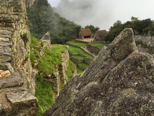
Machu Picchu means old peak and is a 15th-century Inca site located at 2,430 metres. It is situated on a mountain ridge above the Sacred Valley which is 80 kilometres northwest of Cusco and through which the Urubamba River flows. Most archaeologists believe that Machu Picchu was built as an estate for the Inca emperor Pachacuti (1438–1472). Often mistakenly referred to as the "Lost City of the Incas" (which is what Hiram Bongham was actually searching for when he stumbled across it), it is the most familiar icon of Inca civilisation.

The Incas built the city around 1450, but abandoned it a century later at the time of the Spanish Conquest. Although known locally, it was unknown to the outside world before being brought to international attention in 1911 by Yale Professor Hiram Bingham (on whom apparently Inidiana Jones was modeled). The city was in disrepair and most of the buildings have been reconstructed in order to give tourists a better idea of what the structures originally looked like.